Northeastern Olympics Loop: Solo

2009 Trip Planning

For the last year, I’ve been planning our annual, week-long backpacking adventure with my mates McL and Franken. Planning involved numerous gear purchases chronicled here, including a new sleeping bag, pad, cape, steripen, etc. Training included numerous training hikes also chronicled here, including weekly trips on the Marquam and Wildwood trails and a couple of ascents on NW Mountains. Mountain climbing was really only a series of rest stops on the road to a lengthy backpacking trip as only the latter provides enough time away to purge the daily grind from my inner being!This year it seemed certain that we were headed for the Graves Creek Trailhead and the Enchanted Valley/LaCrosse Basin loop. I had given up my goal of completing the ~45 mile Northeastern Olympics Loop in 2009 as a result of Frank’s desire to return to the Enchanted Valley. These plans, it turned out, would crumble as a result of McL’s quadriceps muscle and Frank’s work priorities. Given that I dropped considerable coin and time in planning/preparing for a trip and that we had already agreed on a mid-September date, this didn’t provide many opportunities to rethink the plan as pushing to October would bring uncertain weather and harsher climes. It did, however, provide enough time for me to realign my sights on the Northeastern Olympics Loop for a second time in 2009!

2009 Trip Re-Plan

When all else had failed and before I had formally asked, Flight suggested that I take the trip by myself after discussing what had transpired with a girlfriend. I didn’t even need to make a pitch/plea for this to happen! This is where I had to put aside any doubt in my ability to conduct this hike . . . solo!. This would be my first solo hike. In bear country. Without a companion to share a laugh, thoughts on which way to travel, or a yell should a bear invade our camp ground! People that I discussed this with, outside of BPL, thought this plan to be crazy. I would be joining an elite status of backpackers who forgo companions and rely solely on their skills and experience while on backcountry jaunts!

Upon receipt of a “go” from Flight, I placed a call into the Wilderness Information Center in Port Angeles, WA. I spoke to a ranger named “Ranger Smith” and our Conversation went as follows:

Ploss: Hi, I’m planning to hike the Northeastern Olympics Loop from Deer Park>Gray Wolf Pass>Dose Meadows>Cameron Pass>Grand Valley>Hurricane Ridge>Deer Park in three days. What would you recommend?
Ranger Smith: I can’t make any recommendations as I cannot assess your fitness level.
Ploss: I’m only asking for recommendations on where I should stay for the two nights and I’d prefer to not carry a hard-sided container unless there’s no other option. The park website indicated that I should call to get the latest information on park bear wires.
Ranger Smith: There’s bear wire in the Dosewallips area at Bear Camp and at the lakes in the Hurricane Ridge area. The problem is that there’s not suitable trees in the high country around Gray Wolf Pass. Falls Camp is really your last best location before the high country unless you can make it 20 miles to Bear Camp.
Ploss: I was hoping to travel ~13 miles on day 1. Are there no other places where I can hang before Bear Camp?
Ranger Smith: As long as you can hang 12 feet up and 10 feet out from the nearest trunk, your food is legally stored per park regulations.
Ploss: What about my second night? Where would you recommend that I stay? Grand Lake?
Ranger Smith: I’d recommend Moose Lake as it’s in higher country. Let me check if there’s availability. Yes, there’s availability on 9/13.
Ploss: Okay, let’s go with Moose Lake. That’ll be a tough day! How is the water situation on the trail?
Ranger Smith: The only area where there isn’t a lot of water is the Hurricane Ridge section of the trail, beyond Grand Lake if you’re headed out via Obstruction Peak. I’d recommend that you carry two liters of water for that section of the trail.
Ploss: Thanks.
Ranger Smith: Also, I also recommend that you park near the ranger station at Deer Park when you arrive and hike east to the Three Forks trail head for your departure. This way, you’ll arrive at your car when you return to Deer Park rather than having to hike the last .5 miles on the road.

Ranger Smith was extremely helpful and charged me a total of $9 for my permits (a $5 Wilderness permit with a $2 per night fee). I was able to pay over the phone and he emailed me my permit! This would save me from having to handle this the morning of my hike and thus save precious time given a 4.5 hour drive from Portland to the trailhead. On paper, this appeared to be a pretty brutal hike given the 45 mile length with 12,000 feet of elevation gained in 3 days. My camp locations would dictate how far I could travel and just how long my second day would be with more than 20 miles between Falls Camp and Moose Lake! With all that said, I gathered up all of my belongings and assembled my grub for the trip, including an assortment of oatmeal, GU, bars, and two freezerbag dinners (pasta with pesto and cous cous w/vegetables).

Day 1: Saturday, September 12, 2009

I departed at the brutal time of 4:15am on 9/12 traveling on I5 to Olympia, WA and heading north on Hwy 101 beyond Sequim towards Port Angeles. I made the left turn onto Deer Park Rd and drove 16 miles to Deer Park @ 5300ft, arriving at 8:45am, ready for my hike!


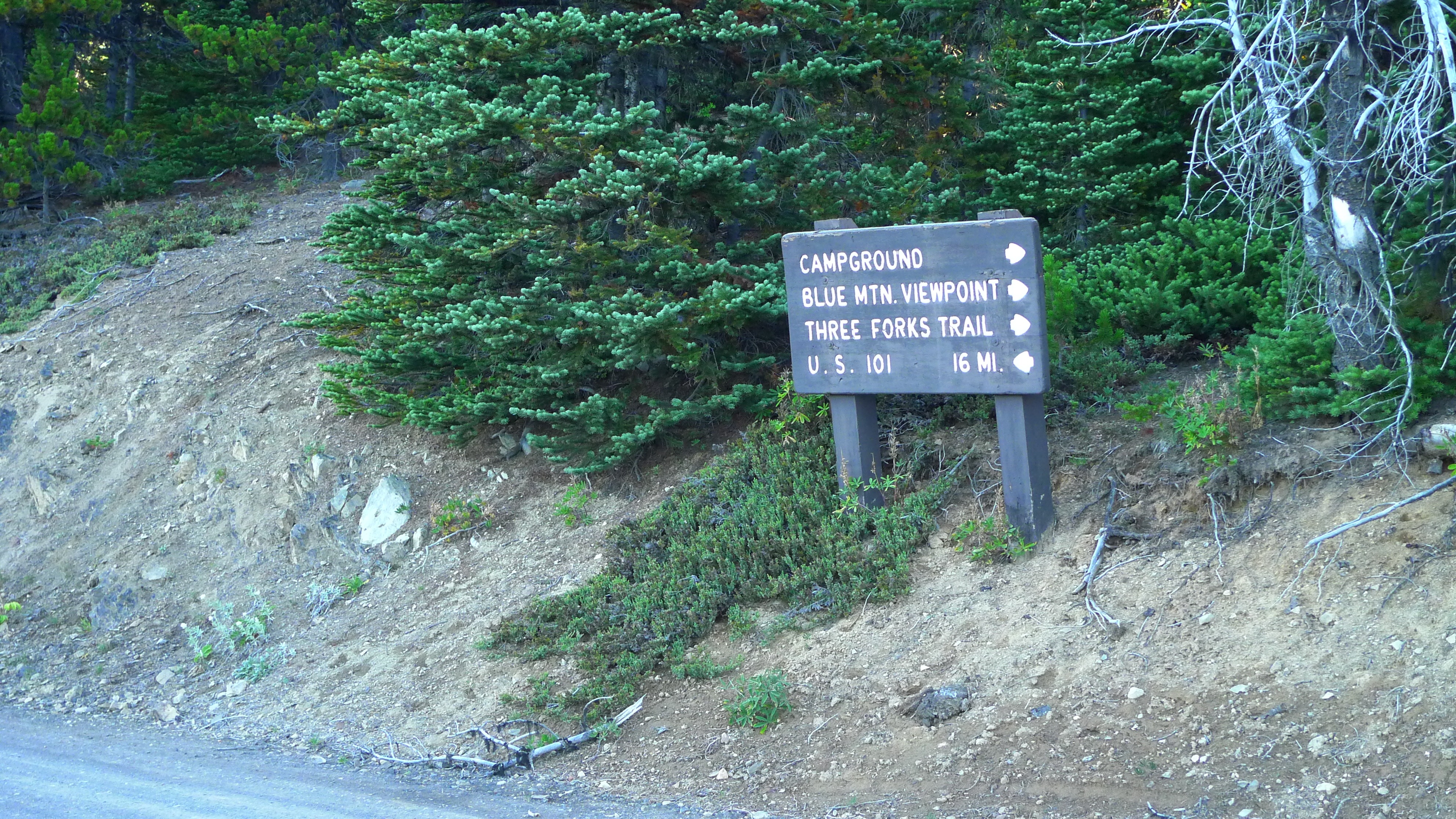
First sign of the Three Forks trail as I was hiking from the Ranger Station parking lot

Per Ranger Smith’s direction, I hiked the .5 miles on the road to the Three Forks trail. It was better to “suffer” this section of the hike first, rather than last! The Three Forks Trail starts with a 3300ft descent to Three Forks camp at the confluence of Grand Creek, Cameron Creek and The Gray Wolf River.

I saw three hikers that were completing the loop in counter-clockwise fashion on my descent. They had spent about 7 days on the trail and they looked as if they had been beaten down, probably because it’s a steep ascent from Three Forks Camp to the trailhead! Upon hearing what I was planning for this hike, they thought I was nuts when I told them that I was trying to reach Bear Camp for my first night! This was a foolhardy goal indeed, as I would find out later on . . ..

I reached Three Forks Camp at ~11am, having traveled about 5.2 miles. This is where I made a critical navigational error and took a right on the Cameron Creek trail instead of heading south on the Gray Wolf River trail. I “knew” that this didn’t feel right within about 15 minutes, but I assumed that there would be additional signage along the way. I hiked for an hour on the Cameron Creek trail before I confirmed my error with a review of my map and turned around for the hour hike back to Three Forks. This cost me my goal of reaching Bear Camp and added ~4 miles to my total mileage. NAVIGATIONAL FAIL!!


I misinterpreted the sign to read that a right turn would take me to both the Greywolf and Cameron Creek trails. Note that the signage is inconsistent in its spelling of gray/grey!

When I reached the Greywolf trail, I was discouraged. It was 1pm. I’d nearly traveled 10 miles and had to travel another 5.7 miles to Falls Camp. This is where it would have helped to have a companion with me, for hopes that together we would have been able to decode the signage to find the right route the first time. Bear Camp was definitely out of the question as a day 1 goal!

I met two additional hikers on my way from Three Forks to Falls Camp. A pair of dudes were hiking the loop from Obstruction Peak counter-clockwise and another triumvirate was traveling with a handfull of mushrooms towards Three Forks. I didn’t inquire about their bounty, but assume that it was mushroom season. I reached Falls Camp @ 4:14pm, bringing my mileage total to between 14-15 miles.


The remains of Falls Camp Shelter. Apparently the fire only destroyed the shelter and its denizens.

At Falls Camp, the question really was a matter of how far I should try to go on day 1, recognizing that day 2 would be brutal with 4 mountain passes to overcome. Had I studied my map more closely, I would have realized that the Cedar Lake trail was nearby, but I missed this section due to the fact that there wasn’t any signage indicating this. As such, I continued on a path towards Gray Wolf Pass, carefully reviewing the tree-line for places where I could hang my food for the night.

I hiked for an additional 2 hours fifteen minutes until I reached a row of trees near 5000ft. There were a couple of camp spots and trees that could be used for hanging a bear bag. I estimate that I traveled another 4 miles for a total of 18-19 miles for day 1. I had hiked pretty-much nonstop for almost 10 hours and had gained about 4000ft total in elevation. I hung my bear bag first using the PCT method and proceeded to make dinner and setup camp. Needless to say I was effing tired!


Successful bear bag and in accordance to park rules!


Camp for night 1: only a bivens was used due to lack of available energy!


A black-tailed deer that wanted to chill with me at my camp! I’ll note that my camera has only 2.5x zoom!

This is when things got interesting. This was the first night that I’d ever spent alone in the wilderness. While I’d normally listen to tunes at night, I didn’t consider this to be an option due to the risk of having to defend my campsite from a marauding bear. This didn’t happen, fortunately, but my black-tailed deer friend traveled through my campsite all night long which made for a sketchy sleep at best! I’m not sure how much I slept, if at all. I’m not sure how much of that was related to being alone or just being outdoors (on the WLT last year, I didn’t sleep that well either). Regardless, I made a plan to carry a sleep aid such as Tylenol PM on my travels moving-forward.

Day 2: Sunday, September 13, 2009

I got up promptly at 6:30am and began the process to lower my bear bag. Due to my novice knot tying around the stick suspending my bear bag, it took me almost 30 minutes to get to my belongings. I finally had to break the stick to remove it and lower my food from the bough above. I would have enjoyed having Frank’s knot knowledge so that I could have gotten an earlier start, but oh well, it was a successful hang!

I threw down some dry oatmeal and a Gu2o and packed up my belongings for a rough day 2! I brushed my teeth with Dr. Bronners soap, which was not too bad. It would have been worse had I not traded in my prison-issue toothbrush for this trip.

I got back on the trail just before 8am. Looking down as I was ascending Gray Wolf Pass, I realized that I had camped next to a tarn, a small pool on the hillside. While I wouldn’t call this a FAIL, it was not my most observant moment, but I must admit that I wasn’t looking to gain any additional elevation on day 1!


Oh my, I camped next to water last night. Bloody hell!

From here, I climbed up to the top of Gray Wolf Pass @ 6150ft. This would be the first of four passes in between my starting location and Moose Lake. WTF was I thinking??? It was about a mile from the tarn to the summit.


Gray Wolf Pass @ 6150ft


Photographic proof that I actually was there at Gray Wolf Pass!

From here, I descended 2500ft to the Dosewallips trail which was full of meadows and campsites with bear wire! This area was very similar to the meadows of the Enchanted Valley/LaCrosse Basin area. Although the signs indicated that the nearby areas had been destroyed by a wildfire, there was no sign of any damage on this portion of the loop!


Fluffy little clouds and green valleys!

I reached Bear Camp at around 11am. It was a nice camp with several sites, bear wire and a shelter with bunks. While a shelter would generally sound like a good idea, they are full of rodents. The shelter at Bear Camp, in particular, had much evidence of mouse feces on all of the nearby wood. Olympic Park shelters, while nice to look at, are definitely not places where I’d like to stay for a night!


Bear Camp Shelter: fun and mouse feces!

After a quick break, I made a dash for Dose (pronounced Dosie) Meadows for lunch, around noon. Another beautiful meadow, again, with bear wire! These were a couple of areas that would have been worth a longer stay. Unfortunately, I’d only made it over my first of four passes for the day and hiked only 7.9 miles, so could only afford 30 minutes of rest; this did not afford me with an opportunity to see one of the bear that apparently frequent this area! I’ll note that by this point of the trip, my food was no longer appealing and I realized that my meal plan would no longer work for me on these trips. I NEEDED SOME REAL FOOD (not that I could do anything about it)!


Dose Meadows. As fine as any other meadow that I’ve seen in the Olympics!

Fortunately I had a break before I climbed Lost Pass! While only 1100ft higher than Dose Meadows, it was a near-vertical trail for ~1 mile!


Mount Claywood from Lost Pass

Next up: Cameron Pass. Cameron Pass, one of the highest passes in the Olympics @ 6450ft, is nearly 2 miles and 1500ft higher than Lost Pass. It afforded me with a view of a nice meadow adorned with myriad blueberries for my enjoyment! And I did enjoy! I reached the pass just before 3:30pm, bringing my mileage total to about 10.8 miles for the day. I made poor time for this section of the hike and had to hike an another 7.3 miles to the bear wire that had my name on it! I knew at this point that this would be a LONG day.


Cameron Pass. I had to fix the sign for this photo! Mount Olympus is in the back.

Lucky for me that I could descend the “trail of shale” in the afternoon. This was a pretty treacherous descent for about 800ft with large patches of snow aligning the trail. The trail meandered through the Cameron Basin, through varied terrain, including beautiful waterfalls.

Water stop @ 4:30pm!

Posted in Backpacking, Olympic NP | 1 Comment

Mount St. Helens Climb – August 30, 2009

I must admit that my attitude related to climbing the Oregon/Washington peaks has been somewhat ambivalent as chronicled in this blog. As noted in my post from the Adams Climb, I’ve moved slightly up the continuum towards excitement regarding these adventures! That said, I had an opportunity to join my brother and a team of non-technical climbers in their quest to climb (aka conquer) Mt. St. Helens on August 30th! I gladly joined, in spite of input received from Franken regarding climbing the Mountain during the summer months–described as “HELL” due to the huge amount of ash and/or scree near the rim. This would be an opportunity to buck the trend!

This adventure started with an 11:30am departure on Saturday from Portland. It’s about a 1.5 hour drive from Portland to Cougar, WA and we arrived around 1pm at the permit location, the Lone Fir Resort. First off, the Lone Fir was killer and I cannot adequately describe how nice the owners were to us and everyone else at the restaurant. They were extremely concerned about the quality of our experience there and identified quickly that my brother was not the most adventurous eater, validating that his simple cheeseburger met his high specifications! While the menu was rather simple, the food was excellent! Here we met our team leaders, Gary and his wife Dixie, before we departed for the Climbers Bivouac.

From the Lone Fir, it’s about a fifteen minute drive to the Climbers Bivouac. It’s a mostly paved road from Cougar and our destination was a mere 6 miles from Ape Caves. Mostly. The Bivouac consists of a large loop parking lot with numerous camping spots for aspiring climbers. We selected a site very close to the trailhead that would accommodate a total group size of 11. Numerous circus-variety tents were erected at this location and we prepared for the arrival of the other members of the team.

The weather on the Mountain was gloomy on Saturday. We hiked from the Bivouac (elevation 3800ft) to the tree line @ 4700ft and met many hikers along the way. Versus Mt. Adams, these hikers were very happy as they had tamed the mountain, only missing the complete experience of seeing the dome and views of Mt. Hood, Adams, and Rainier due to ~30 yards visibility! Versus, Mt. Adams, these hikers didn’t demonstrate the same level of bitterness, due primarily to the fact that they made it to the rim. This was nice as a pre-hike hike as it’s only 2 miles to the tree line and the elevation gain was extremely gradual!

Given that this was car camping, and probably just shy of glamping, the accommodations were not meager. Our climb leader brought a ton of wood for the fire pit in his truck. We had two, two-burner Coleman stoves. My brother’s tent, as an example, had a doggie-door and zippered compartment for a power line. He brought a fold-out mattress suitable as an extra bed for house guests as his sleep pad. For dinner, we had pesto and fresh bread. I’m clearly not used to this when doing my ultralight backpacking thang!

Fortunately, just like in the case of Mt. Adams, the weather cleared in the evening and we were greeted by fantastic weather for our hike. After a standard breakfast of dry oatmeal and a honey gel, which, by the way, was greeted by heckles from the rest of the team, my brother and I headed for the trail at 7am. The rest of the team had things like eggs and ham and other bed-and-breakfast fare and departed, at minimum, 30 minutes later. The departure time, I’ll note, was net of an outhouse shad by my brother (this, I’ll note is very similar to hiking with McL due to his bowel “opportunities”).


A Clear View of the Mountain

From here, we hiked the same initial section to the tree line from the previous day. Only thing that I’d note is that the first two miles are extremely mellow and not much more demanding than the worst Marquam or Wildwood trail sections. From the treeline to approximately ~1000 vertical feet of the summit, the trail quality quickly degenerated into a boulder scramble for 2 miles. This was pounding and rendered my poles unusable. The trail, if you could call it that, was identified by wooden poles spread regularly up the mountain. There were areas in the valley below the poles that was more trail-like, but it was a bit better to travel over the rocks than through the ash/sand that comprised the trail.


Downward view of the ascent up the rocks


Mondo-condo, boulder field HELL!

After an hour plus climbing up the rock pile, we reached the land of motherscree and ash pie! While certainly not as pounding as I had previously heard, it was a slow ascent from the edge of the rocks to the crater rim. This portion of the ascent wasn’t really lengthy in terms of mileage, but it took some time to make it to the rim’s edge. I would call this section a complete slog!


View of the ash/scree field leading to the rim

From here, we finally reached the rim at 10:30am. This is where things were the most gnarly due to the fact that the true summit is actually pretty far to the west of the initial arrival position. There were portions where the trail was completely exposed and it would be easy to fall, not into the crater, but down the side of the mountain towards the Dryer Glacier. In addition, there was a steep section of rock to descend, making this the most challenging section of the hike in my opinion.

We reached the true summit around 11am and snacked on treats that we had brought. Mine consisted of a Payday bar and some gorp. My brother enjoyed a PB&J sandwich, although I brought several different candy bars to celebrate the occasion! A bunch of people paraded through while we chilled for a half-hour or so.


View of the dome, Spirit Lake, and Mount Rainier

Observations:

  • If I were to do this hike again, I’d definitely wear trail runners. Boots were not required on this hike even with an amount of scree/ash to ford. Gaiters would be a required addition to this setup.
  • I would have made better time had I left my bivy sack, sleeping bag, pad, stove, clothes, and assorted items back at camp. I estimate that my total weight was approximately 15 pounds.
  • While certainly not a technical climb, it was challenging due to the rock field and rim section.
  • I recommend this climb for summer as it would be treacherous during the winter. The summit would be a risky/steep endeavor and one would not be able to approach the rim for fear of snow cornice breakage/risk of a painful fall into the crater.
  • There’s a loop around the mountain called the Loowit Trail. The Wonderland Trail it is not, with a total mileage of 28.62 miles.
Posted in Mount St. Helens, Mountaineering | Leave a comment

BPL STIX Mod: Aftermarket Tips

As the resident gear whore at Smackpacker, I decided that I needed to lower my gear worn/carried weight a few months ago and started to procure lighter clothing, a new iPod, a new camera, etc. When Backpacking Light offered their 2009 STIX carbon fiber poles at an incredibly cheap price of $53.99, I couldn’t resist trying out these 8.2 oz poles (pair). I bought the 115cm length due to the fact that this pairs well with my Six Moon Designs Gatewood Cape.

Upon receiving these poles, I couldn’t help but notice the interesting design of the pole tips: instead of offering a replaceable tip, the poles tapered all the way to an integrated tip. While this is clearly the lightest option, it is certainly not the most durable. People on the interwebz have been covering the carbon fiber tip with heat shrink as a lightweight protective solution.

Stock tips do not offer much protection to the carbon fiber pole that is joined to the tip–once the carbon fiber is damaged, the pole is done

Another solution is to remove the basket and overlay an aftermarket Leki tip over these poles for an increased length of ~4.3cm. I will show how to do this in picture format!

The first step of this is to place the basket on the basket collar. This provides some leverage to remove the collar from the poles and create the length necessary for sliding on an aftermarket tip.

Poles ready for modification

The second step is to grab the pole handle in your left hand (if right-handed), and use the basket to loosen the collar, removing it from the pole. This is very easy to do as you can see from the photo below as there’s only a small amount of glue on the pole to secure the collar to the pole.

Pole without basket collar

Once this is done, simply place some leki replacement tips over the end of the poles, pounding them into the ground, tip first, several times.

Fully-modified poles, ripe for some hiking!

Note: this modification adds just over 4cm of length to the poles. This created a slightly longer pole than I’d prefer, but that’s a trade-off that I gladly made due to the length required to erect my cape. After this modification, I’ve used the poles on several hikes and they worked flawlessly! It’s really surprising how much easier it is to use a featherweight pole. While they certainly aren’t bombproof or as stowable as an adjustable pole, these poles fully meet my needs and divided my pole weight in half!

Posted in Gear Reviews | Tagged , , , | 2 Comments

Mount Adams South Climb – June 19-20, 2009

Franken, our resident mountaineer, has had his sights fixed on the summit of a glaciated peak for many, many months. He spent the first four months or so of the year in a brutal Mazama training regimen to prepare him to ascend Mount Hood. As chronicled on this blog, I joined him on several preparatory hikes, including Ruckel Creek, Kings Mountain, and the famous post-holing trek to Twin Lakes. This goal led him to Mount Hood, only to be turned back a few hundred feet from the summit. How would I tell him to respond after having his hopes dashed due to the whims of Mother Nature? “You get your ass out there and you find that f**kin’ summit!”

Over the course of the year, our collective mountaineering goals have waned. The three of us originally had our sights on Mount Adams, the 12,281 ft behemoth in Southern Washington, as a celebratory statement for our 40th birthday year. Instead, my “mountaineering” coin went to ultralight backpacking gear and McL’s plans became assigned to the Olympic Peninsula. McL went as far as to assign a likelihood of “probably not” to the ascent. I must say that my desire to bag a bunch of peaks went from excitement to ambivalence as I didn’t want to risk our annual backpacking trip with an injury suffered mountaineering.


Probability of McL ascending Mount Adams–not probable!

There were many obstacles in our way of summiting Mount Adams. The first was a complete lack of mountaineering gear in my possession. The second was Frank’s desire to bring his black lab, Rudy. The third was an extremely narrow summit window of Father’s Day weekend (or Father’s Day weekend). The fourth was typically heinous weather in June. The fifth was the fact that the road to Cold Springs Campground, the starting point of the South Route (trail #183) was buried in snow, and would require an addition 3-5 mile hike to reach the trailhead from the closed access road.

These obstacles gradually were overcome. Happy Gurl loaned me an ice axe and Frank loaned me his aluminum crampons; Frank eventually had a break in his cloud of confusion and decided that it would be a poor idea to bring his dog with us; the weather forecast, the most important factor in any summit attempt, provided one sunny day on Saturday, forcing us to move our ascent up by one day and allowing me to attend the annual golf outing with my father; and the road to Cold Springs opened up two days before our climb! Over the week preceding the summit bid, my excitement returned as my first summit became a tangible and achievable goal!

On a dreary Friday, June 19th, we left Portland for Trout Lake, Washington. Located approximately 2 hours from Portland, Trout Lake is a small town located at the foot of Mt. Adams. Upon our arrival, we found the ranger station and purchased two climbing permits @ $15 apiece and received a couple of pack tags and poo bags in return for our coin. From there, we drove ~25 minutes up a gravel road to the Cold Springs Campground where there were, surprisingly, a bazillion cars. Franken and my outfits were juxtaposed against one another with Franklin donning an ultralight poncho and my shell consisting of heavy, triple-layer gore-tex.


Wimpy, wimpy, wimpy (ultralight goodness)


Hefty, Hefty, Hefty (non-ultralight shell)

From trailhead #183, we departed @ ~10:30am. The trail was mostly covered in snow even from the starting elevation of ~5,600 ft and we trudged our way up the old road to the timberline. We encountered many dejected climbers on the trail. A couple of dudes carrying a slider that said they had to turnaround due to a blizzard at 10,000 ft. We ran into a couple of jokers who, although they didn’t reach the summit, stated that it was 75 degrees at lunch counter and there was an espresso stand! While I typically appreciate some well-timed sarcasm, this was a bit lame in the face of two eager climbers who were looking for a bit of good news! It didn’t help that there was an additional forlorn gentleman who looked as if he had been through a laundry spin cycle. As far as we knew, none of the people who had attempted the summit had succeeded on the 19th, yet still we trudged along.

We followed the cairns through pounding rain for several miles and finally the weather cleared enough for us to reset our attitudes. It was tough mentally to hike with base camp pack weights up the trail to lunch counter in driving rain. Although the pleasant weather only lasted for a half-hour or so, it was welcomed and recharged our batteries.


Perhaps the weather for this climb will not be so git?

Unfortunately this all changed for the thousand remaining feet leading up to Lunch Counter. The sun was replaced by windy conditions and driving rain and snow out of the west. I was often in my pack grabbing different gear to confront the varied conditions of the mountain, be it my shell, gloves, goggles, bandanna, etc. Fortunately I carried everything that I needed, but didn’t have any place very handy to store it during the ascent. At approximately 4pm, we reached Lunch Counter (elevation: 9,300 ft where we camped), a rocky portion of the mountain with many campsites consisting of sandy ground shielded from the west with windbreaks constructed of rock piles.

Rather than camp in a designated campsite, Frank elected to choose a snow patch for erecting the North Face mealy grub ™ tent. We had split the weight of the tent in two for the ascent with Frank carrying the rain fly and poles and I carried the tent. Instead of bringing 5 one-ounce snow stakes, Frank brought five bags and some string to fill with snow and bury to secure the tent. This is a good idea for saving weight, provided that you don’t bury the bags three feet in the snow! Frank used his shovel to create a bumpy platform for the tent. After a half-hour and several unsuccessful attempts at securing the luffa sponge attachment, we had a base camp!


The photo: (1) makes the weather look good and (2) makes it look as if the luffa is actually attached to the tent

At base camp, our activities consisted of (1) jamming to tunes on my iPhone, (2) melting snow on Frank’s sno-peak stove, and (3) fantasizing that the weather would support our climb on Saturday. My meal consisted of a 500 calorie Mountain House Grilled Chicken Breasts and Mashed Potatoes meal for two one. Frank’s meal consisted of a 1000 calorie Backpacker’s Pantry Chicken Saigon Noodle dish. It didn’t help that he wasn’t feeling very well due to the altitude, but he suffered a 1,000 calorie intestinal pounding as well. My meal’s grilled chicken was curious as the instructions stated that you should hydrate the chicken first and take it out of the package, then add the potatoes and once cooked, return the chicken to the pouch. WTF? Do you think I brought a freaking ultralight kitchen to prepare my meal? I skipped this step and once the chicken was cooked, dumped all of the potatoes in. Still it was quite a good meal!

I used my Z-lite pad for my insulation layer with a NeoAir for comfort. This setup worked really well and was very warm even with my 20-degree Nunatak quilt. Frank, conversely had a single pad that leached moisture into the bottom of his sleeping bag throughout the night. The entire bottom of his bag became soaked during the night. I had a fitful “sleep” and probably got about four to five hours in total. This was, perhaps, due to the altitude. I woke Frank up around 4am for our preparation. He suffered a bit to get ready and was almost in a McL-like state as he tried to pull together his gear. This is atypical for Franklin and he was clearly suffering a bit  from the altitude. He complained of a head and stomach ache at around 9,000 ft onwards, but desired to forge ahead as planned. This didn’t, however, have an effect on his ability to drop a morning load from his evening meal. Frank made short work of a poo bag in the morning in preparation for the summit!

We donned light pack loads for the summit bid and wore crampons, making a “charge” for the false summit @ Pikers Peak around 5:30am. From Lunch Counter, one cannot actually see the true summit of Mount Adams and is led to believe that Pikers Peak is the final destination. The temperature dropped below freezing overnight and the snow had a hard ice shell. This section of the climb was extremely steep and I felt very uneasy on this section of the hike. My boots didn’t seem to enjoy the crampons very much and the front portion of the crampons slid to the side, making me feel as if I could easily fall! I continuously had to adjust them to prevent a crampon FAIL. It was this feeling that accompanied me as we duck-walked up to Pikers Peak, planting our ice axes directly in front of us and taking two angled steps up the mountain.

At this point of the climb, we were passed by 2 mountaineers (AKA zealots) from Colorado who passed us as if we were standing still on the mountain. We passed a couple of dudes from Seattle who started their hike around 11pm on Friday. They were clearly bonking on this section of the ascent and complained that the pitch here was steeper than anything that they experienced on Rainier on Memorial Day weekend! Although I have no basis for comparison, I will agree that the pitch was extremely steep!


^#$*#^$*^$# False Summit @ Pikers Peak


Grim pitch leading up to Pikers Peak


Although I’m smiling, I’d like to be the F off of this mountain!

Reaching Pikers Peak (11,600 ft), we could finally see the true summit some 700 vertical feet away. At this point, I was feeling really tired and had to commit, hard, to make the push onward. The snow, due to the sun, became a thick powder and it became tough to use crampons. I nixed them as a result. The Colorado dudes passed us a second time on their descent as we ascended the summit. They were on a weekend trip and planned to summit both Adams and Hood on the weekend. I guess it makes a big difference to be acclimated when you live near so many 14ers! One dude spoke of how he made a killer Goo (seemingly like the killer eggnog made with lighter fluid) that he was going to give to the bonking mountaineers below us! It’s pretty cool how everyone looks out for one another on the mountain and was encouraging for me as but a learner!


First glimpse of the true summit from Pikers Peak and a corresponding dip in my mental attitude

At around 9:40am, we reached the summit of Mt. Adams and stood on the historic fire lookout that was built in 1921. Apparently the site was used as a sulfur mine back in the 1930s. We became the third group to summit the mountain on June 20, 2009!


The buried fire lookout


Summit from atop the fire lookout (note: not the actual summit according to topo maps)

It’s important to note that the fire lookout isn’t the actual summit, so we hiked the 30-40 yards to the officially recognized summit! The glaciated peak that had eluded Frank for so many months was conquered and this would make him eligible to finally join the Mazamas. We met two other groups after about 20 minutes and shared some wasabi peas, gorp, and chocolate that Frank brought for the peak! Thanks Franklin! One group was from Tennessee and traveled to Seattle to summit Adams, Hood, Shasta and Rainier. They only had Rainier left on their itinerary by this point!!!

From here, we plunge-stepped down to Pikers peak and began the descent down the steep pitch to our basecamp. We had figured it was still too icy for glissading, but after I saw the dudes from Tennessee doing it, I followed shortly behind. Instead of using the glissader ™ that Frank built and that I carried on this entire trip, I slid on my ass down the mountain for about 2,000 ft. It was pretty difficult at first and due to the incline I felt pretty exposed to a wipeout. Frank’s glissader/sleep pad failed on his descent and ended up neither functioning well as a sleeping pad nor a glissader. This was freaking awesome and well worth the price of admission!


Glissading . . .. Takes me away to where I’ve always . . .


Frank employing the Ploss method!


Adams elevation profile

We descended to Lunch Counter to disassemble the tent, boil some water for Frank, and load our packs for the descent to 5,600 ft. As noted previously, the bag filled with snow method is killer as long as you don’t bury the bags under 3 feet of snow. This common sense, I’ll note, eluded Franken. Given that the weather was very sunny all day and that the sun shone directly on our camp for several hours, this created a packed slush and we literally had to excavate the bags to leave no trace of our visit. This required his snow shovel and the picks of our ice axes to complete the job and was like working a full day walking the beat and then having to mine coal. Anyway, I performed the majority of this duty while Frank tended to his water needs/modified his glissader and we packed up all of our gear for going down the mountain.

From lunch counter, there were still some amazing sections for glissading, probably about 2,000 more feet or so in total. We saw multiple people ascending the mountain, ski mountaineering or traveling with snow boards. Saturday really brought out the trogs to the mountain and we were happy to be going the other way. I’m happy to say that my shell pants made it without any rips or tears after protecting my gluteus maximus for ~4,000 vertical feet.

We finally reached the Cold Springs Campground about 2:30pm on Saturday and were greeted by a parking lot full of hikers who were traveling to various portions of the mountain. Frank parted ways with me to go deposit his bag of feces near the toilets and I returned to the car to chat with a couple of dudes who were preparing to camp at the timberline and ski down the mountain on Sunday. We really got to chatting with a bunch of peeps on the mountain and versus backpacking, the people climbing the mountain really bond together. Perhaps it’s the danger or moxie involved in ascending glaciated peaks, but we and the people we met were very willing to share a tale or two about how we “tamed” the mountain if for only a brief span of time. The end definitely justified the means and while I’m certainly not in a hurry to climb another peak, I will gladly accompany Frank on his next peak of choice. We had a great time on the mountain and leveraged the skills acquired over many, many seasons of backpacking to their fullest extent!

Observations:

The hardest decision for Frank was where to locate his bag of excrement. He planned to attach it to the outside of his pack, but I pleaded with him to put it inside, stating that I didn’t want to stare at his shite all the way down the mountain. After thinking this through fully, he obliged.

All-in-all, the south climb approach of Mount Adams was accessible and challenging at the same. I must say that building base camp at the Lunch Counter was a wise call and provided us with the opportunity to lighten our loads, escape from the grim weather, and acclimatize a bit. Hiking it in June, while providing a challenge in the weather window, allowed us to avoid the hassle of dealing with mixed terrain and make the entire hike in snow. This, of course, made the climb more challenging due to the extra energy expenditure required to climb in deep snow.

  • My Six Moon Designs Starlite pack was perfect for winter backpacking. The aluminum stays and large pack volume (4200 ci) were well suited for this adventure, weighing only 30 ounces with stays (not including the z-lite pad)! There was ample room for all of my gear and the large side pocket could fit my glissader upright.
  • The NeoAir worked very perfectly. I disagree with many reviewers who have dogged it due to complaints of a narrow width and loud, crinkly material. It fully met my “lofty” expectations.
  • My Nunatak Arc Alpinist quilt was also perfect for this pursuit, keeping me warm and dry during the night.
  • Melting snow with a gas canister stove takes a long time. The GSI kettle worked very well for pouring out melted water, but the volume for winter camping is a bit low. The crown jewel, apparently, is a white gas stove for pumping out serious BTUs required to melt snow. I’d recommend a two liter titanium pot for serious winter camping!
  • From a clothing perspective, everything worked really well, although I could have used a lighter shell. A wind shirt probably would have met my needs for the most part, although it would have likely leaked on Friday. Combined with a wool base layer, a level of dampness would not have mattered.
  • An ultralight CAMP Corsa ice axe would have met my needs, but I can’t complain about the Black Diamond Raven Pro. Fortunately I didn’t need to self-arrest on this trip as I have no experience doing it! If I’m going to do more climbing, I will probably stay away from an aluminum ice axe head as it is nowhere near as functional on ice as it is for snow. As such, I’ll probably be picking up a Raven Pro as it’s the lightest ice axe that works well in icy conditions.
  • I’m not the biggest fan of the CAMP Crampons. Perhaps my displeasure was a result of Frank using larger boots with them or perhaps I was doing something wrong. They did the trick though and saved a lot of weight, but I didn’t really feel comfortable in them.
  • For glissading, I think my Snow Claw Guide Snow Shovel would have worked very well. Although I didn’t need anything under my butt, it’s small and sturdy enough to make a future trip!


Mount Adams South Climb GPS Route

Posted in Mount Adams, Mountaineering | 1 Comment

Now I know how Ed Viesturs Felt the first time on Everest

So the short version:  We were within 300 vertical feet of the summit, and had to turn back due to ice fall.  Below is he story in gory detail.  I know this is another “dear diary” but I feel like sharing :).

This appeared to be the perfect situation for making a successfull summit of hood this spring.  There haven’t been nearly the normal number due to the freak storms causing high avalanch danger and the interspersed heat waves that have caused excessive ice fall.  Two people were injured this past weekend due to this.  Today, however, was supposed to be the best shot for the next couple of weeks due to the storm that dumped rain on Portland tuesday, but was supposed to leave “minimal” snow on Hood (~0.5 inches).  After the warm weather, the snow was consolodated and the avalanche danger would be low.  Plus, the cold front would keep the ice together on the crater rim.  The weather forcast and or the thought process was a bit wrong.  Here is what happened:

We left Timberline last night in a total blizzard with a temperature of 29.  I thought the climb leader would call it, but we went forward as the weather was supposed to clear.  After hiking in conditions I wouldn’t even ski in for about 3 hours, we reached the top of the Palmer snowfield and indeed, the snow subsided and the stars came out.  However, the cold did not stop, but this was part of the plan.  After donning crampons at this point, we made our way up around crater rock.  The sunrise and the very crecent moon were great.  Up there, you can see the entire moon with the sun shining on the small part.  Kind of looks like a death star.  From there, we made our way up to the Hogsback.  The entire time it was getting colder and colder.  When we stopped at the bottom of the Hogsback to eat, put on our harnesses and rope up, it was 10 degrees with 20-30 MPH winds.  This corresponds to a -12 wind chill factor.  I had my gloves off for about 1-2 minutes and really frost bit them.  They are still purple and num on the tips.  Roped up, we ascended the Hogsback and cut over left to go up the “Old Shute”  we had just gotten onto the shoot and by this time the sun was rocks and warming up fast.  Now we had the opposite problem.  After about 15 more minutes, a few chunks of ice began to fall.  At this point, we could make the Summit, but probably not make it down safely.  As we started decending, the sun started hitting the 2 ft (not 0.5 inches) of fresh snow that had fallen and was now being warmed.  Avalanches most commonly occur between 30 and 45 degrees.  However, apparently 38 degrees is the sweet spot for slopes.  The slope we had to go under is 37 degrees.  If we would have gotten caught up in an avalance there, we would probably be washed over the cliffs directly below the formed gully.  So now we in a rush just to get out of the crater.  The final loosener was the fact that Timberline has put the kybosch on glissading in their “area”  This meant it was only safe to glissade a short distance above the Palmer chair lift.  From there, with the increased heat and intense sun, I totally burned the bottom of my nose and the inside of my nostrils.

This is definitely the most physically, and possibly emotionally demanding things I have ever done.  It was a lot of work to get so far and come up short.  However, at least I am back in one piece.  I will post some photos soon.

Posted in Mount Hood | Leave a comment

April 20th

Looking at the calendar this morning, I realized it was time for a new gear rant. It’s funny how much changes in a year: a year ago in this space I rambled on for twenty sentences about…my REI Galaxy Pack?!? My REI Cruise 60 “UL” pack?!? WTF?

These days, I’m a fully converted exacto knife-wielding gram counter, and rather than explore the relative “merits” of a 4 lb. 11 oz backcracking behemoth vs. a 3 lb. 2 oz. “ultralight” alternative, I’m going to look at a more pertinent backpack comparison: the 1 lb. 6 oz. 2008 GoLite Jam2 pack vs. the 1 lb. 10 oz. 2009 GoLite Jam2 pack.

In an age where I’m trying to not only save every precious ounce but every precious dollar, why would I even consider spending $125 for a newer version of a pack I bought less than a year ago? I mean, for $105 sure – that’s only four hundred and twenty quarters after all – but it’s going to take some serious upgrades to get me to add 4 ounces for that extra 20 bucks.

Plus I still need to buy mountaineering glasses

The 2009 Jam2 does indeed include some improvements worthy of consideration:

  • “…new foam padding in the back for support
  • Brock™ foam padding in the spacer mesh shoulder straps for long-lasting comfort
  • More storage options exist with the addition of hipbelt mesh pockets, granting easy access to food and essentials without ever having to take off the pack
  • Store larger items you want quick access to in the large front pocket and two side angled stretch mesh pockets.
  • Reduce excess pack room as your trip goes on by utilizing the two side compression straps and the comPACKtor system.

Let’s start with the first item: Ploss provided a verbal (loser) trail report about his experience on Ruckel yesterday sporting a Therm-a-Rest Z-Seat in lieu of the stock back padding provided in the 2008 Jam2. It’s unclear from the descriptions alone how much the 2009 padding differs from the 2008, but given that Ploss gave his Z-Seat upgrade a thumbs up in conjunction w/heavy compression, new foam padding seems unlikley to be necessary for me, either.

I’ve been pretty happy w/the Jam2’s shoulder straps – really have had no complaints in terms of comfort, and since my maximum pack weight should be 23 lbs. at most with a week’s worth of food and a liter+ of water, do I need better strap padding? What is Brock™ foam?

Brock Foam is a softer foam. EPS, like in bicycle helmets, is a harder foam. The softer foam is better for smaller impacts, like generally cruising around the mountain. A harder foam is better for one big impact, like dropping cliffs. After one big hit on EPS foam, the cells crush completely, and should be thrown out. Brock foam recovers from impacts, and such, can take multiple hits better.

Okie dokie. Better? Maybe? Let’s move on to the hipbelt mesh pockets which had been something I really thought would be a useful improvement – one of the things I actually really do appreciate about the REI Cruise 60. But then I bought the Simblissity UnSlack Pack:

This thing arrived on Saturday, and is killer. Weighs 1.1 oz on my new digital scale and has more than enough storage space for my new camera, a bar or two, a 0.2 oz. dutch key, and anything else I might need. Let’s say I piled said 6 oz. camera, two 2 oz. Lara bars, a 0.5 oz. lip balm and…my SteriPEN Adventurer into it…which would easily fit…I’d have about 15 oz. (420 g) of easily accessible kit and grub at my immediate disposal. This would seem to negate the need for hip belt pockets.

The last two bullet points pertain to key features already found on the 2008 variety Jam2, namely the mesh side pockets and comPACKtor system, both of which are key. Water bottles are easily reachable from the mesh pockets, and the compression system provides for maximum weight distribution and frameless comfort when packing your UL gear sensibly; Ploss reported that by using the compression system to its fullest he was able to carry about 5 days’ worth of food comfortably at the bottom of his pack yesterday, allowing him to avoid over-compressing his BPL Pro 90 quilt.

Conclusions: even though I have a sick, sick gear addiction it’s clear that while the 2009 GoLite Jam2 pack is well worth your consideration if you don’t already own one (go buy one now), it probably doesn’t offer enough for me to buy a whole new one and risk getting my effing @$$ kicked by the wife who would clearly and understandably not understand why I need two Jam2s. For once, taking twenty minutes to think through this potential upgrade served me well, and while I had intended to post this later in the day, I’m going to be locked up in the four o’clock hour and simply didn’t want to pass up an opportunity to pad April’s post numbers, which you can peruse over on the left right hand side of the blog.

Posted in Gear Reviews | 1 Comment